
Palo Duro Canyon in Texas is America’s 2nd largest canyon, and one truly impressive canyon it is! Not only that, it’s 120 miles long and is America’s 2nd largest State Park. It’s a park you could spend days in, hiking all the different trails! If you’re doing Route 66, then it is the perfect day out. The park is located just a 30 minutes drive from Amarillo.

Best Time Of Year To Visit
The best time to visit is from March to April, or October to November. Summers are very hot and can make hiking difficult. Even as early as May, when we visited it was hot! Often on the trails, there’s very little shade from the sun.
Park Fee’s
There is a small fee to pay to visit Palo Duro Canyon State Park. At the time we visited in May 2022, it cost us $8 each for the day. Kids under 12 do go free.
Park Opening Hours
The park is open from 7 am till 9 pm, daily.

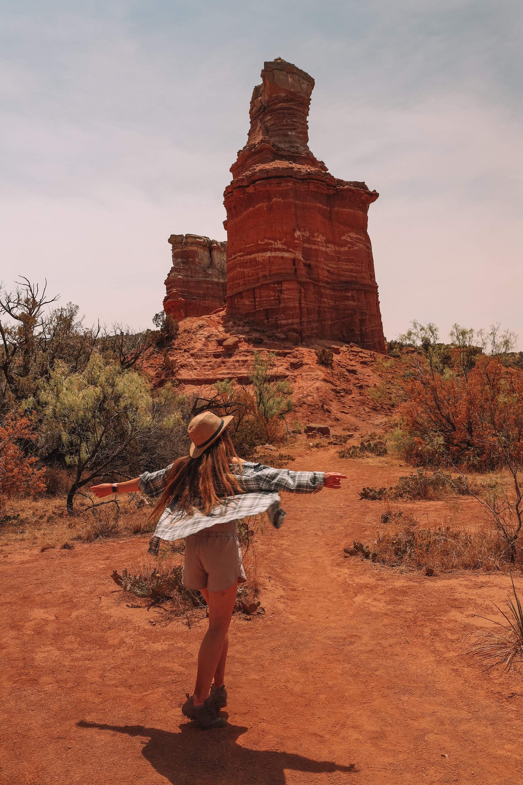
Hiking The Lighthouse Trail
If you are in the park just for one day only, then this is the trail to do! The hike was incredible from start to finish! However, if you are planning on hiking this trail, get there early as the car park does get full quite quickly!
The route is 6 miles out-and-back moderate hike, with a tiny bit of scrambling up to the Lighthouse rock. It’s not a particularly strenuous hike, however, the heat can make it feel a lot harder! Make sure you’re carrying plenty of water, covered in sun cream, and wearing a hat. Starting the trail early morning or later in the day will also help, as you’re avoiding the hot, midday sun. Also, check the weather forecast before you set off. The last thing you want is to be caught out in a thunderstorm. Also, make sure you have good footwear on your feet. I recommend wearing a good pair of hiking shoes, and not sandals, as the area is home to snakes.


Parking
The Lighthouse trailhead has its own small, well-marked car park. It’s located just off the Palo Duro Canyon loop road, west of the park.

The Route
Follow this map, as you walk the route, you shouldn’t get lost! Make sure your location is turned on and you should be able to see exactly where you are, on this map. Or if you prefer, download the GPX file and use it on your choice of route tracker.
1.
Starting in the car park, head over to the start of the trailhead, marked Lighthouse Trail. Follow the dust path until you come to a folk junction.


2.
At the folk junction, take the path going off to your right-hand side. Follow the path as it curves around large, impressive canyon rock formations. The path will then lead you along the canyon, and up to the Lighthouse rock formation. The last part is quite steep, and some scrambling will be required, but nothing too difficult/technical.


3.
Once you’ve finished enjoying the views at the Lighthouse, start your return journey back to the car, retracing your steps.


For more information on the park, including some of the other viewpoints you can visit/walking trails to do, please head to their website: https://palodurocanyon.com/
If you would like to be notified when any new travel guides go live, straight to your inbox, please subscribe here:
(don’t forget to check your junkbox for the confirmation e-mail!)
Further Reading
My book, How I Tamed the Wolf, Living with Lupus is available on Amazon via this link:
https://www.amazon.co.uk/dp/B09M73X2JQ/ref=cm_sw_em_r_mt_dp_MWAF58981F0VVMNRV1WN
Other travel guides you may like:
Chicago – 48 Hours in Chicago
St Louis – Incredible Gateway Arch National Park, St Louis
Miami – https://livingwiththewolf.co.uk/miami/
New York – https://livingwiththewolf.co.uk/new-york/


