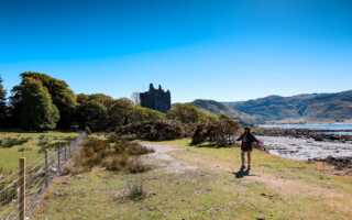
A beautiful hike in the Howardian Hills, Area of Outstanding Natural Beauty (AONB). The Howardian Hills AONB sits in between the Yorkshire Dales National Park and the North Yorkshire Moors National Park, in North Yorkshire.
The 7-mile circular takes you along edges of fields, from woods, cattle fields, pass a pig farm, and up onto the rolling hills. The walk starts and finishes in the quiet village of Terrington, taking around 3-hours to complete. It is a lovely quiet walk to do, away from the crowded walking trails, in National Parks.
Parking
You can park along the main street in Terrington, free of charge, and for as long as you need. We did the walk on a Saturday in August and there was plenty of parking available.

The Route
Follow this map, as you walk the route, you shouldn’t get lost! Make sure your location is turned on and you should be able to see exactly where you are, on this map. Enjoy!
1.
From the Village of Terrington, head up Church Lane, until you reach a footpath at the bottom of the lane, on the left-hand side of a house. Take the path which will lead you onto the playing field. Follow the footpath along the right-hand side of the playing field, until you reach the farmer’s field.


2.
Follow the footpath down the right-hand side of the field and into the next field. Then follow the footpath round to your left-hand side, walking along the edge of the field. Eventually, you will reach a little stream with a little wooden bridge. Cross the bridge and head towards the gate, leading you into what was a cattle field at the time we were there.


3.
Head through the cattle shield for a very short distance, keeping to the right-hand side of the field. Head through the gate and follow the footpath up to the farm track. Turn left onto the farm track and walk along the track until you reach a farm track going off to your right-hand side.


4.
Take the farm track off to your right-hand side and follow it along the side of the woods. Eventually, you will see a path leading off to your left-hand side. Take the path and follow it past the farmhouse, through some more woods, and towards the pig farm.


5.
Walk past the pig farm, keeping the pig farm on your left-hand side and head into Slingsby Banks Wood. At the path junction, take the footpath on your right-hand side. Follow it through the woods until you meet another footpath, going off to your right-hand side. The path should be descending down through the woods and out into a clearing.


6.
Follow the footpath, along the edge of the woods, keeping the woods to your right-hand side. Follow the footpath into Callis Wood and through to Bell Bottom. Eventually, you will reach the Public Bridleway. Turn left onto the Public Bridleway and follow it for a very short distance, until you see a footpath going off to your right-hand side. Take the footpath and follow it down to the road.


7.
Cross over the road and take the footpath. The footpath will lead you around the edge of the field, next to Cum Hag Wood and through a cattle field. Before reaching the gate out of the cattle field, you should see a footpath on your right-hand side. Take the footpath and walk around the edge of the field, before joining the road. Turn left onto the road and follow it back into Terrington. Use the map above, so you don’t get lost.


If you have enjoyed this walk and would like to see more of my walking trails, click on this link: https://livingwiththewolf.co.uk/hiking-trails/
For more information on the Howardian Hills, please visit their website: http://www.howardianhills.org.uk/